Noise pollution is a growing environmental problem in urban and industrial areas, affecting residents’ wellbeing, quality of life, and environmental health. Noise exposure can have long-term consequences including hearing loss, increased hyperactivity in children, and even hypertension. The European Union has implemented a directive to address this situation in cities and diminish the harmful effects of noise pollution. A new approach to this problem is being carried out by the Faculty of Geo-Information Science and Earth Observation at the University of Twente through OGITO: Open Geo-Spatial Interactive Tool. Considering noise pollution affects multiple stakeholders, the researchers have embraced a collaborative approach in two ways: by involving the users in the design process of the tool itself and by supporting stakeholders’ input for decision-making in urban planning.
OGITO
Addressing urban challenges, such as noise pollution, demands the collaboration of different backgrounds and perspectives to gain a better understanding of the situation around the city. In recent years, maptables are more frequently being used to support collaborative processes in the spatial planning domain. These devices display geospatial content (e.g. specific city maps) in a digestible format for lay persons to interact with the content via the touch screen.
Maptables allow to present the highly-technical content as easy-to-use materials that promote communication and understanding among stakeholders and researchers. However, software modifications are usually necessary to improve user usability of existent open-source software solutions.
The aforementioned limitations are addressed in the design of OGITO, Open Geo-spatial Interactive TOol, through co-designed modifications to the digital interface. This tool provides a map-based visualisation of the area under discussion in accordance with an ISO usability framework. Creating an intuitive and usable maptable interface is essential for data collection, if users cannot understand how to use the tool then they are limited to the information they can provide to urban planners and researchers.
Designing OGITO with users
The research group integrated a Human-Centred Design methodology with Agile development software methods. This combination aims to strengthen stakeholder participation during the design process, an essential step for interactive tools. Users can get involved at different stages of the design process depending on the input necessary at any given stage. The combination of both approaches resulted in six different goals for stakeholder involvement during OGITO’s design process:
1. Understand and define the context of use
2. Define user requirements
3. Generate design solutions
4.Evaluate design solutions
5. Evaluate under controlled conditions
6. Evaluate during workshop with users
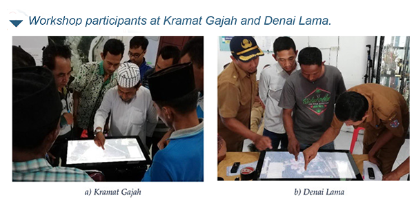
To collect the necessary feedback, researchers organised focus groups, face-to-face meetings, and workshops with different stakeholder groups depending on the goal at hand. The research had Sumatra, Indonesia as a case study to develop the first iteration of OGITO. Participants were local residents in Denai Lama and Kramat Gajah, spatial planning researchers, technical experts in geographic information systems (GIS), and application developers. Stakeholder feedback, filled with unique perspectives and insights, has been essential for the development of the final version of OGITO. Involving other voices in the process led to the creation of a lightweight application with a simplified interface which provides the necessary functionality to satisfy both users and stakeholders. The usability of the maptable further considers those who have not used a maptable before as these users could use OGITO without assistance during community mapping workshops.
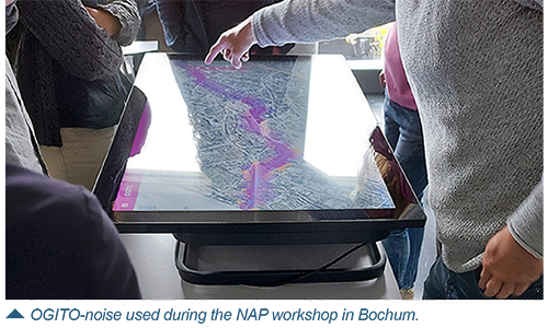
Noise action planning with OGITO users
Stakeholder involvement, during the research phase of a project, can highly benefit the project as the different experts can join the discussion and share their day to day experience with noise exposure and management. Researchers further tested OGITO to support noise action planning (NAP) in Bochum, Germany as a case study of the interactive tool in use for collaborative planning. During the workshop with current stakeholders, OGITO-noise was used to collect participants’ perspectives of the acoustic environment in different areas of the city and supported the discussion of potential interventions for noise reduction.
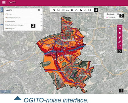
The use of maptables during spatial and urban planning allows participants to interact with spatial information about the city in a different way. Through the embedded tools in OGITO-noise, users can identify noisy areas, noise sources (e.g. roads, factory), mark relevant roads, highlight the difference between day-evening-night noise levels, and visualise the estimated population exposed to noisy roads. The digital nature of this tool allows for future integration of map data sets, CAD files, and 3D-view integration.
The results from the research indicate that an HCD+Agile approach is meaningful for developing usable and useful planning support tools such as maptables. Interactive tools such as OGITO have the potential to include a diverse group of experiences by bringing together citizens, environmental professionals, city planners, NGOs, politicians, local transport companies, municipality departments, and researchers into the spatial planning discussion. The research project exploits the benefits of spatial visualisation capabilities and digital technologies to create an interactive tool designed with citizens for citizens.